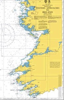
From Mizen Head to the Connemara coast
For lovers of peace and quiet wishing to sail off the beaten track, the West coast of Ireland is one of the finest cruising areas in Europe. This wild and rugged coastline is rarely visited by yachtsmen. Yet it has much to offer to experienced crews prepared to take on the Wild North Atlantic. Several beautiful bays (Bantry Bay, Kenmare River, Dingle Bay, Galway Bay, Clew Bay) provide sheltered cruising areas, and plenty of remote and beautiful anchorages. The richness and diversity of marine wildlife here are also astonishing: seals, dolphins, seabirds of all kinds, and even whales abound along this coast.
Approaching Mizen Head (the southernmost tip of Ireland) is straightforward: the coast is well lit, and there are no offshore dangers other than the famous Fastnet Rock, 8 miles south-east of Mizen Head, which has a lighthouse. Note that the tidal streams are strong along this coast. They flow eastwards or northward on the flood and westwards or southwards on the ebb, reaching speeds of up to four knots near Mizen Head. They can cause dangerous seas in heavy weather or when there is a westerly swell against the ebb. In such conditions, it is best to stay more than five miles off Mizen Head. Should bad westerly weather make passing Mizen Head difficult, it is always possible to seek shelter in Crookhaven, 5 miles north-east of Mizen Head, and, as a last resort, Baltimore harbour, 20 miles east of Mizen Head, is accessible in all weathers, day or night.
Dunmanus Bay and Bantry Bay
Dunmanus Bay, just north of Mizen Head, offers only a few wild and very isolated anchorages (in Dunmanus hrbor and Kitchen cove), and once past Mizen Head, the best option is probably to continue on to Bantry Bay, which offers several magnificent and very well-sheltered anchorages.
Bantry harbour is accessible in all weathers, but night entrance is not recommended as there are unlit fish farms to the east of Whiddy Island.
It is usually possible to tie up at the floating pontoon on the right-hand side of the harbour entrance, or, if there is no space there, at the floating breakwater to the north of the entrance. The inner harbour dries out. The nearby town is very lively, and there is an excellent market (organic produce, local crafts, etc.) every Friday, as well as several supermarkets, including one on the harbour. It is also one of the best places on the West Coast to top up with diesel, as there is a petrol station directly opposite the floating pontoon. Showers are available at the Maritime Health and Fitness Centre, just past the Maritime Hotel, 100 metres from the marina towards the town.
It is also possible to anchor outside the harbour, or to the east of Whiddy Island and leave the dingly at the floating breakwater.
Gengarriff, north of Bantry, is another anchorage offering perfect shelter from all winds. Its wooded shores are breathtakingly beautiful and well worth a visit. Adrigole, on the north coast of the bay, is another very beautiful anchorage, well protected except in strong southerly winds, but quite isolated. Perfect for lunch, but you’ll probably prefer to spend the night anchored in Glengarriff, or alongside in the small marina at Lawrence Cove, on the north coast of Bere Island. Castletownbere is a very busy fishing hrbour and is not recommended for yachtsmen, except perhaps for a short stop to do some shopping (there’s a large supermarket and a good hardware store next to the Bere island ferry dock). It is not usualy possible for yacht to come alongside in Castletownbere harbour. There are (free) visitors mooring East of Dinish island, but it’s a long way to town with the dinghy, going under the bridge which connect the island to the mainland, but the dinghy can be safely left at the floating pontoon near the Bere Island ferry dock.
There’s a beautiful anchorage in Dunboy Bay, with room for one boat, but mind the drying rock in the middle of the bay: stay close to Dunboy point as you come in.
The Kenmare River and the Skelligs
If continuing North towards the Kenmare River, it is possible to take a shortcut through Dursey Sound, inside Dursey Island, but the channel is narrow, the tidal streams are strong, there is a dangerous rock in the channel, and the clearance is limited to 21 metres by the cable car serving the island. If you prefer to sail outside Dursey Head, be sure to admire the spectacular natural tunnel that cuts through Bull Rock.
There is no marina and no facilities for yachts in Kenmare River, but it offers superb, very well sheltered natural anchorages: Ardgroom and Killmakiloge on the south coast and Sneem on the north coast. These anchorages are difficult to access as there are few marks, but many rocks, so the Irish Cruising Club guide is strongly recommended. Peace and quiet are guaranteed; even in the height of summer, very few pleasure craft visit this area.
Derryname, at the northern mouth of the River Kenmare, is a spectacular anchorage and offers excellent shelter, but night entry is not recommended, even though there are leading lights: the entrance is extremely narrow and is dangerous in bad weather or when there is a south-westerly swell. Once inside, the shelter if excellent. Anchor on sand bottom, or borrow a mooring, You can have a hot shower at Keting Bar.
Further north, Ballinskellig Bay offers a temporary anchorage when winds are from the North.
It’s rarely possible to land on Skellig Michael (Great Skellig), but it still well worth the detour to marvel at the courage of the monks who lived for several centuries on this isolated rock in the middle of the Atlantic and to admire one of Europe’s largest colony of gannets on Little Skellig.
To the south of Valentia Island, the small harbour of Portmagee offers excellent shelter, and there is even a floatting pontoon for pleasure crafts, with water and electricity, opposite the village; although in summer, it may be hard to find a space as it is used by the ferries serving the Skelligs. It is also possible to anchor in Reencheragh Bay, to the west of the village, good holding and tranquility. The entrance of Portmagee shouldn’t be attempted at night or in heavy westerly weather.
Dingle Bay and the Blaskets
Dingle Bay is home to two of the few marinas on this coast. On the north shore of the bay, the town of Dingle is the commercial hub of the entire peninsula and a major centre for traditional Irish music. The harbour, which is very well sheltered, is a major fishing port, and access is easy day or night, whatever the weather. The town is lively and pretty, and boasts several large supermarkets, excellent shops (including a cheese shop, ‘The Little Cheese Shop’, which specialises in Irish cheeses – well worth a visit), good restaurants and, of course, plenty of pubs. There is no diesel available at the quayside, but there is a petrol station just past the fishing harbour, and you can borrow a trolley from the marina to fill up using jerry cans.
On the other side of the bay, Valentia provides excellent shelter, accessible day or night in practically all weathers except heavy north-westerly swell (in which case Dingle offers better shelter anyway). The area is much quieter than Dingle. On the east coast of Valentia Island, the pretty little harbour of Knightstown offers a floating jetty for pleasure. craft, with water and electricity at the quay.There is always space available, but there are no shops nearby. There are several possible anchorages in the bay, including an excellent one in northerly winds, in the small bay to the south-east of Beginnish. It’s a peaceful spot, but for shopping you’ll need to sail up the river to Caherciven marina or, better still, cross the bay to Dingle.
To the north-west of Dingle bay, Ventry is an excellent anchorage in northerly winds, and a very useful stopover if you need to wait for the tide to turn before going through the Blasket Sound.
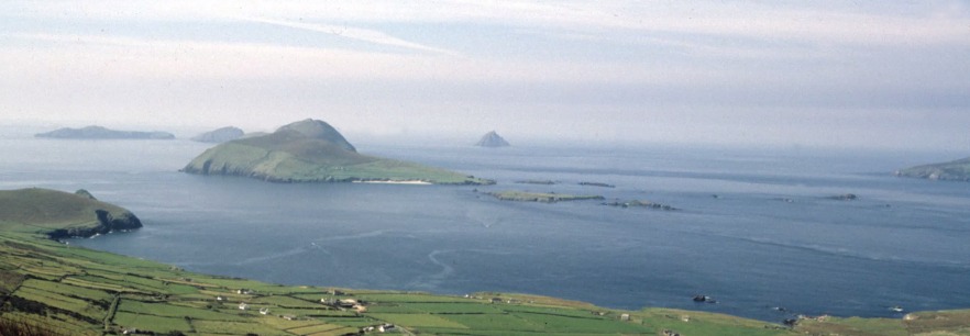
In fine weather, the Blasket Islands, abandoned by their last inhabitants in 1953, are well worth a visit. It is possible to anchor temporarily off the long sandy beach East of Great Blasket (in the centre of the photo below).
Blasket Sound
Tidal streams are strong in the Blasket Sound, so it is best to wait for the flood (which flows northwards). The passage is relatively well sheltered from the westerly swell by the islands, but the sea is often rough off Sybil Point, the Northern entrance of the sound, if there is even the slightest swell. The Blacket Sound is unlit, and although it is relatively wide, it would be unwise to attempt it at night.
Continuing north past the Blasket Sound, possible stops include Smertwick Harbour, a few miles north-east of Sybil Point, which offers several pleasant anchorages and is very well sheltered from southerly winds, but is completely exposed to the north-west. Further north-east, the small marina at Fenit is 30 miles from Blasket Sound, and Kilrush Marina, at the mouth of the River Shannon, is 50 miles away; however, there is no safe shelter between the mouth of the Shannon and Galway Bay, only a few fine weather anchorages (at Doonbeg, Mutton Island and Lahinch). As this is generally a lee shore, most boats prefer to sail directly from the Blaskets to the Aran Islands, a crossing of over 60 miles.
The Aran islands, Galway, and the South Connemara coast
On the Aran Islands, only Inishmore, the largest of the three islands, has a proper harbour (Kilronan), as well as a quiet anchorage, well sheltered from southerly winds, opposite the beach in Kilmurvey Bay. To visit the other islands, it is best to take the ferry.
Kilronan, the main harbour on Inishmore, lies to the north-west of a large bay that is very well sheltered from southerly and westerly winds. You can anchor anywhere in the bay on firm sand, excellent holding or take a visitor’s mooring (free of charge) to the south of the ferries’ jetty. It is also possible to come alongside the concrete pier in the inner harbour and take the ground on a clean sandy bottom there. The anchorage at Kilronan can be rolly with a north-westerly swells and becomes untenable in heavy north or north-easterly weather. In such cases, it is preferable to shelter in one of the many harbours and anchorages along the south coast of Connemara: Cashla Bay (Rossaveal) is accessible in all weathers, day or night. Vessels wishing to call at Rossaveal Marina are requested to contact the harbour master’s office before arrival: , or +353 87-22584. Water and electricity are available at the quay.
Kilkieran Bay offers several remote and well-sheltered anchorages. Navigation into Roundstone is tricky, and holding is poor at the anchorage opposite the quay, but the village is very picturesque. To the west of Roundstone, Gorteen Bay offers a magnificent and well-sheltered anchorage, opposite a large sandy beach. Bunowen Bay, 5 miles east of Slyne Head, offers good shelter from westerly or northerly winds and is a good place to wait for a fair tide to round Slyne Head. The entire southern coast of Connemara between Cashla Bay and Slyne Head is a maze of rocks and islands which, in fine weather, will delight those who enjoy pilotage, but should be avoided in bad weather or when there is swell.
To the East of the bay, Galway Harbour has a small marina in the floating dock, accessible from two hours before high tide until HW (when the lock closes). It’s right in the city centre and peace and quiet aren’t guaranteed, but the city’s best pubs and restaurants, as well as Ireland’s finest cheese shop (Sheridan’s – don’t miss their selection of Irish farm cheeses) are just a few minutes’ walk away. The facilities offered by the marina are very limited: there is water at the jetties and a rubbish bin, but no showers or toilets! Galway is one of the largest cities on Ireland’s west coast and is therefore easily accessible by public transport, making it a good place to change crew or carry out repairs.
It is possible to dry out in Galway’s old harbour alongside one of the old stone quays, but check out the place at low tide first!
South of Galway, the small harbour of Kinvara is a pleasant – if somewhat touristy – village, with good pubs and restaurants. The bay offers several well-sheltered anchorages, and it is also possible to dry out at the quay in the inner harbour.
From Slyne Head to Clew Bay, the West Connemara coast
Slyne Head is a major headland completely exposed to the warth of the North Atlantic, and the tidal streams there are strong, so treat it with due respect. The tidal stream flows northwards on the flood and southwards on the ebb and can cause dangerous seas. If there’s any swell or with the wind against the tide, it is best to stay at least five miles offshore.
In very fine weather with no swell, a very narrow channel – the Joyce Sound – offfers a short cut inside Slyne Head that can save a few miles when coming from the Aran Islands or from a harbour in Galway Bay. Joyce Sound is easier to navigate when approaching from the south, as the entrance is difficult to locate when coming from the north. It would be very unwise to attempt Joyce Sound if there is even the slightest swell or if the wind is stronger than force 4. British Admiralty Chart 2708 is essential.
The first bay North of Slyne Head, Mannin Bay, offers no safe anchorage, but there is a fair-weather anchorage to the south of the bay, just past the entrance, opposite the beach.
Continuing northwards, Clifden Bay offers several very well-sheltered anchorages on hard mud. The entrnce to Clifden Bay is intricate, and is not recommended at night without a good knowledge of the area. At the bottom of the bay, the shelter is excellent in all weathers.
Clifden’s inner harbour is a perfect huricane hole. It is surrounded on all side by high ground and has a very narrow and well protected entrance, but it dries out and therefore can only be entered at the end of the flood. Neither the British Admiralty chart nor the Irish Cruising Club guide provide sufficient instructions; however, for boats that can take the ground, Clifden is an excellent stopover. The shelter is perfect in all weather, and access to the town of Clifden (the capital of Connemara) is easy. Two white beacons mark the entrance to the approach channel. You must wait until the two heads of the rock to the north of the first beacon are submerged. There is then at least 4 feet of water in the channel and alongside the quay. Pass just south of the beacons and then head directly for the very narrow entrance at the very back of the bay. As soon as the quay comes into view, turn sharply to port to pass very close to the first two small stone beacons, leaving them to port, and inside the third, which marks the end of a submerged jetty that must be left to starboard (see the satellite photo on Google Maps, where it is clearly visible), and tie up alongside the old stone quay. It is also possible to anchor south of the old stone quayand dry out there on hard mud. There is a water tap at the quay, and the town – which offers plenty of pubs, restaurants and supermarkets – is just a few minutes’ walk away.
Further north, Admiralty Chart 2707 shows two fair-weather anchorages to the east of Omey Island and Inishturk South, but it is better to spend the night at Inishboffin or Cleggan.
The passage inside High Island is safe, but can be very spectacular in heavy weather. Watch out for the 8.2 m High Island breaker, which breaks intermittently in heavy swell. In calm weather, those who enjoy fine pilotate can try one of the channels east of Friar Island. Chart 2707 is essential for this.
Insibofin harbour offers good shelter and is easily accessible both day and night, except in heavy southerly or south-westerly weather. Please note that the entrance is narrow (although it may not appear to be), and that it is essential to stay exactly on the leading lights, which put you frighteninly close to the rocks on the east side of the entrance (which are steep too, the white paint on the rocks is for the Inishboffin ferry to shine on light on them when entering at night in heavy weather). Anchor or borrow a mooring north of Cromwell castle and dinghy ashore, it is not possible for a yacht to come alongside the ferry pier. There is also a fine anchorage in Rusheen bay, north of Inishlyon, on the East side of the island. It is well sheltered from the prevailing winds, but can get rolly with a Northwesterly swell.
In strong southerly winds, Cleggan offers excellent shelter, and can be accessed at night thanks to the lighthouses on Cleggan Point and Inishlyon. Cleggan is a small fishing harbour and the departure point for ferries to Inishboffin. There is a water tap at both quays, a small supermarket and buses to Clifden. With the exception of the outer end of the western quay, which is used by the Inishboffin ferry, the harbour dries out, mud botttom with a few stones. Unless your boat can take the ground easily, it is best to anchor outside to the North or East of the boats on mooring buoys East of the harbour. The bottom is sand and hard mud and offers excellent holding. Use the dinghy to go ashore, or briefly come alongside to take on water and do a bit of shopping at hight water. Cleggan becomes unsafe in heavy westerly swell, and it is then necessary to shelter in Ballynakil.
The entrance to Ballynakil Harbour requires careful pilotage, but once inside, the bay offers several very pretty anchorages that are perfectly sheltered in all weathers, though quite isolated.
Continuing northwards, Killary Harbour and Little Killary are also well sheltered anchorages, but numerous rocks make their access somewhat tricky, and there are many lobster pots throughout this area and as far as Roonagh Point. Little Killary is one of the prettiest and quietest anchorage on the West coast of Ireland.
Continueing North from there? See the article on Clew Bay